

West to east
Southern Upland Way
Opened in 1984, this demanding coast-to-coast route crosses remote upland country. The last approach turns a national-scale walk into a quiet arrival through fields. L1

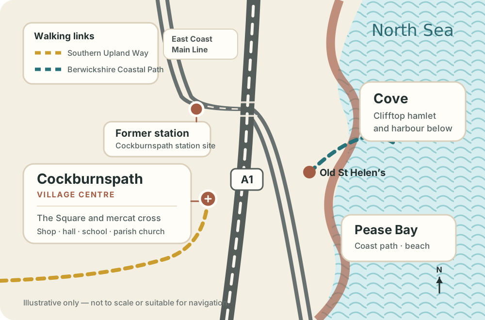
Cockburnspath sits just inland. Cove, Old St Helen’s, Pease Bay and Siccar Point pull the landscape eastward, while the Southern Upland Way arrives from the opposite coast.

Cove feels close to Cockburnspath on a map but occupies a different world: roofs and fields above, then a sudden descent into the enclosed harbour.
The visual drama comes from compression. Cottages are backed by layered rock, small boats sit inside an inlet and the open North Sea is only a short distance beyond the harbour walls.
The harbour is sheltered, but the approach can be steep and wet. Take care on paths and cliff edges, and respect working areas and private homes.
The Southern Upland Way finishes in Cockburnspath after crossing Scotland from Portpatrick, while the Berwickshire Coastal Path continues south-east towards St Abbs, Eyemouth and Berwick-upon-Tweed.
| Route | Official distance | Typical duration | Cockburnspath’s role |
|---|---|---|---|
| Southern Upland Way | 344 km | 12–16 days | Eastern finish, from Portpatrick L1 |
| Berwickshire Coastal Path | 48 km | 2–4 days | Northern start/finish, to Berwick-upon-Tweed L2 L3 |
| Cockburnspath to Dowlaw | 12 km | A substantial day section | First coastal section, with exposed cliffs L2 |
Distances and duration guidance come from official trail sources. Always use current route information, maps and weather forecasts.
Opened in 1984, this demanding coast-to-coast route crosses remote upland country. The last approach turns a national-scale walk into a quiet arrival through fields. L1


A new Deep Time Trail opened at Siccar Point in 2026, and a 51 km cycle trail links Cockburnspath with the coast and Hutton’s Berwickshire farms. C3
At Siccar Point, east of Pease Bay, older steeply tilted rocks meet younger red sandstone—a famous unconformity associated with James Hutton’s arguments for an ancient, dynamic Earth.
The local connection is not just a distant scientific anecdote. A 2026 community newsletter describes the opening of an improved Deep Time Trail, with viewpoints and interpretation, plus a 51 km James Hutton cycle trail beginning at the mercat cross. C3
That route links village, farms and coast, making geology legible as a landscape-scale story rather than a single destination.
Siccar Point is a serious coastal location. Use the dedicated trail and current access guidance; do not descend steep ground simply to reproduce a familiar photograph.
Begin with human time: the planned centre, church and village streets.
Notice hedges, paths and the agricultural frame painted by the Glasgow Boys.
At Cove or Pease Bay, the scale shifts from buildings to cliff and sea.
At Siccar Point, geological relationships extend the timeline beyond human history.
The diagram shows the relationship between the village, railway, main road, harbour and long-distance paths. Use a current walking map for the route itself.
Clifftop routes can be exposed and slippery. Keep back from edges, close gates, control dogs around livestock, carry water and layers, and check live route notices, daylight and weather.